Root Hall
Opening June 5, 2020 through October 4, 2020
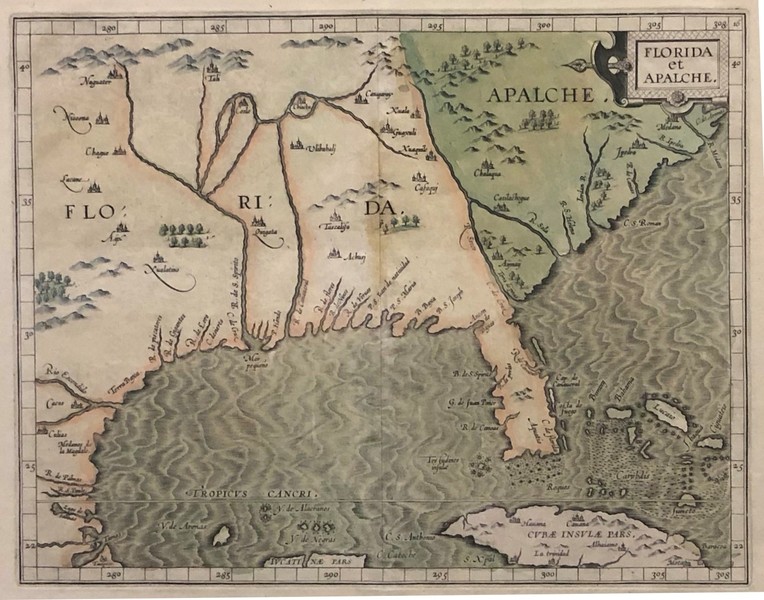
This exhibition of rare vintage maps of our state from as far back as the 1500s comes to MOAS from Dr. Armand and Suzanne Cognetta who have amassed one of the largest collections of antique maps in the country. The exhibition starts with Sebastian Münster’s 1540 map of the Western Hemisphere, the first to treat the hemisphere as a whole and depict the Americas as distinct North and South continents. Given the relative youth of our country, and certainly our state, this exhibition offers a fascinating opportunity to see images of Florida and Southeastern U.S. as Europeans thought of it as far back as the Renaissance. This exhibition is on loan from the Cognetta Family Trust Collection of Tallahassee, Florida,
The exhibition was organized by Curator Angie L. Barry and educational materials provided by archivist Peter A. Cowdry, Jr.
Image Credit: FLORIDA et APALCHE, 1597, Louvain, Belgium, Cartographer: Cornelis van Wytfliet (1555-1597), copperplate engraving, hand colored print on rag paper, From the Cognetta Family Trust Map Collection


 Charles and Linda Williams
  Cici and Hyatt Brown
  North
North  Root Family
  Lowell and Nancy Lohman
 Tuscawilla
 L. Gale